


La grigonnais

Lobin
User
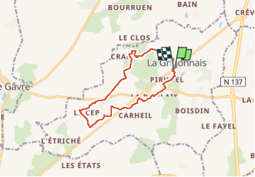

Length
12 km

Max alt
73 m

Uphill gradient
85 m
Km-Effort
13.1 km

Min alt
25 m

Downhill gradient
85 m
Boucle
Yes
Creation date :
2022-09-11 06:54:20.0
Updated on :
2022-09-11 09:08:40.842
2h08
Difficulty : Easy

FREE GPS app for hiking
 SityTrail
IGN / Geographical institutes
SityTrail Plus
The world is yours!
About
Trail Walking of 12 km to be discovered at Pays de la Loire, Loire-Atlantique, La Grigonnais. This trail is proposed by Lobin.
Positioning
Country:
France
Region :
Pays de la Loire
Department/Province :
Loire-Atlantique
Municipality :
La Grigonnais
Location:
Unknown
Start:(Dec)
Start:(UTM)
600215 ; 5264484 (30T) N.
Comments